Kuala Lumpur (KL) topographic map
You can find on this page the Kuala Lumpur (KL) topographic map to print and to download in PDF. The Kuala Lumpur (KL) elevation map present the topography, river and relief of Kuala Lumpur (KL) in Malaysia.
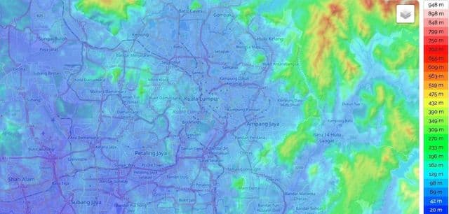
Kuala Lumpur (KL) elevation map
The Kuala Lumpur (KL) topographic map shows elevation, hills and landforms in Kuala Lumpur (KL). This elevation map of Kuala Lumpur (KL) will allow you to know topography, river and relief of Kuala Lumpur (KL) in Malaysia. The Kuala Lumpur (KL) topographic map is downloadable in PDF, printable and free.
Located in the centre of Selangor state, Kuala Lumpur was previously under the rule of Selangor State Government. In 1974, Kuala Lumpur was separated from Selangor to form the first Federal Territory governed directly by the Malaysian Federal Government. Its location on the west coast of Peninsular Malaysia, which has wider flat land than the east coast, has contributed to its faster development relative to other cities in Malaysia. The municipality of the city covers an area of 243 km2 (94 sq mi), with an average elevation of 21.95 m (72.0 ft) as you can see in Kuala Lumpur (KL) elevation map.