Kuala Lumpur (KL) bus system map
You can find on this page the Kuala Lumpur (KL) buses map to print and to download in PDF. The Kuala Lumpur (KL) bus system map and the Kuala Lumpur (KL) trolley map present the network, stations and lines of the buses and trolley of Kuala Lumpur (KL) in Malaysia.
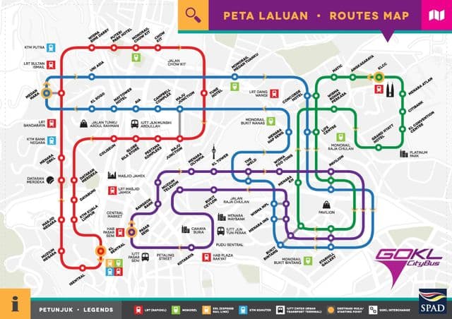
Kuala Lumpur (KL) bus map
The Kuala Lumpur (KL) bus map shows all the stations and lines of the Kuala Lumpur (KL) bus system. This bus map of Kuala Lumpur (KL) will allow you to easily plan your routes in the buses of Kuala Lumpur (KL) in Malaysia. The Kuala Lumpur (KL) bus system map is downloadable in PDF, printable and free.
Kuala Lumpur (KL) local buses (not to be confused with Rapid KL Local Shuttle) or stage buses are run by the integrated network operator Rapid KL as well as privately owned Metrobus, Triton, Len Seng, Selangor Omnibus and SJ Bus as its shown in Kuala Lumpur (KL) bus map. Metrobus and Rapid KL are the two main bus companies within the boundaries of Kuala Lumpur (KL). As there is no difference between public transport in Kuala Lumpur and public transport for the whole Klang Valley, most of the other bus companies other than Rapid KL and Metrobus are normally confined to Klang Valley areas that are outside the boundaries of Kuala Lumpur (KL). The largest operator, Rapid KL, operates 179 bus routes along with the C | Ampang Line, D | Sri Petaling Line and E | Kelana Jaya Line.