Kuala Lumpur (KL) train map
You can find on this page the Kuala Lumpur (KL) trains map to print and to download in PDF. The Kuala Lumpur (KL) trains map presents the rail network and railway stations of the trains of Kuala Lumpur (KL) in Malaysia.
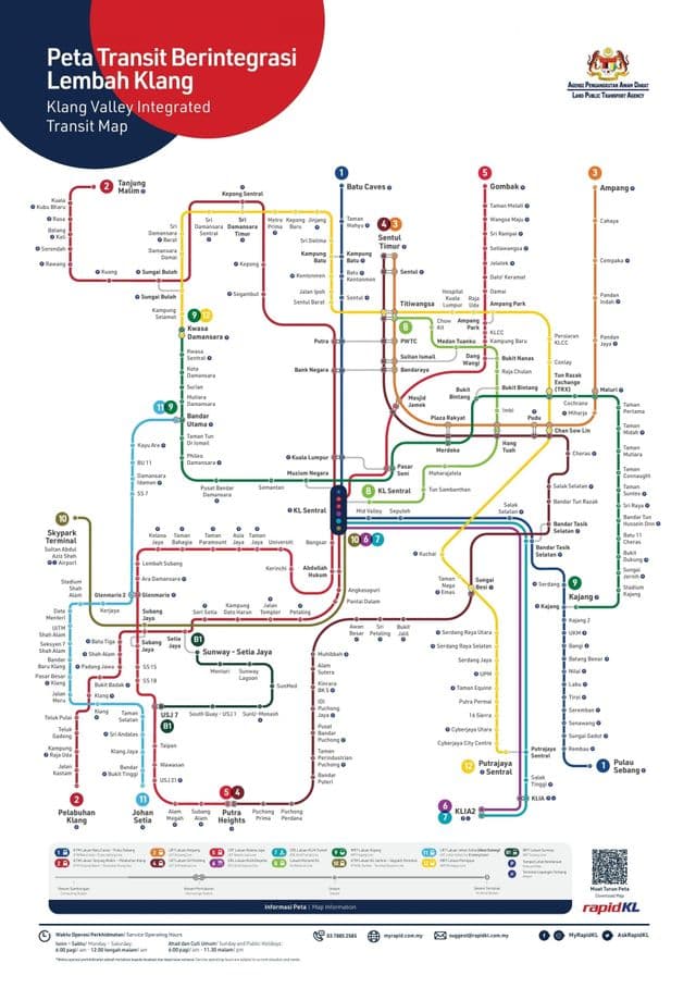
Kuala Lumpur (KL) rail map
The Kuala Lumpur (KL) rails map shows all the railway stations and lines of Kuala Lumpur (KL) trains. This railway map of Kuala Lumpur (KL) will allow you to easily plan your route with the trains of Kuala Lumpur (KL) in Malaysia. The Kuala Lumpur (KL) rails map is downloadable in PDF, printable and free.
There are two fully grade-separated light rail transit systems in Kuala Lumpur (KL). The Kelana Jaya Line and Ampang Line. They are both operated by RapidKL. Kelana Jaya Line is the most important rail line in Kuala Lumpur (KL) as it links Kelana Jaya and Gombak that primarily serves the Petaling Jaya region to the south; southwest and central Kuala Lumpur (KL), and Kuala Lumpur City Centre to the centre as you can see in Kuala Lumpur (KL) rail map. Todate, it carries over 170,000 passengers a day and over 350,000 a day during national events such as National Day celebration and New Year Eve countdown celebration. At 29 km in length, the Kelana Jaya Line is the third longest fully-automated driverless metro system in the world, after the SkyTrain in Greater Vancouver, Canada (49.5 km) and the Lille Metro VAL in Lille, France (32 km). In the 29 km railway line, there are 16 are elevated train stops, and 5 stops between Pasar Seni and Ampang Park are underground. Passengers riding the rapid transit pay with stored value cards such as Touch ’n Go, which are also valid in other transit systems in Kuala Lumpur (KL). Apart from Touch ’n Go, monthly travel pass issued by RapidKL is also accepted to pay fare.