Kuala Lumpur (KL) metro map
You can find on this page the Kuala Lumpur (KL) metro map to print and to download in PDF. The Kuala Lumpur (KL) metro map presents the network, zones, stations and different lines of the metro of Kuala Lumpur (KL) in Malaysia.
Metro map Kuala Lumpur (KL)
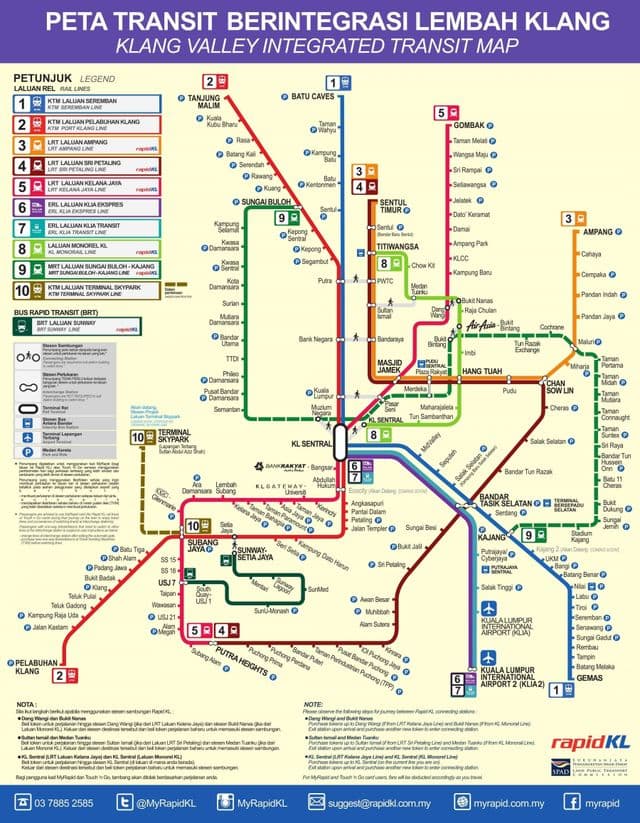
The Kuala Lumpur (KL) metro map shows all the stations and lines of the Kuala Lumpur (KL) metro. This metro map of Kuala Lumpur (KL) will allow you to easily plan your routes in the metro of Kuala Lumpur (KL) in Malaysia. The Kuala Lumpur (KL) metro map is downloadable in PDF, printable and free.
Kuala Lumpur (KL) metro or rapid transit system consists of 6 metro lines operated by 4 operators as you can see in Metro map Kuala Lumpur (KL). Among the 4 operators, RapidKL and Keretapi Tanah Melayu are the most important rail operators in Kuala Lumpur (KL) where Keretapi Tanah Melayu alone carries 30,934,651 passengers in year 2005. Metro lines in Kuala Lumpur (KL) are categorized into different types: light rail transit, commuter rail, and monorail. Others such as the Intercity rail and the airport express are obviously not metro systems. It may even be argued that commuter rail services from Kuala Lumpur (KL) cannot be considered a metro system because it extends far beyond Kuala Lumpur (KL) and its immediate surroundings.
Kuala Lumpur (KL) subway map
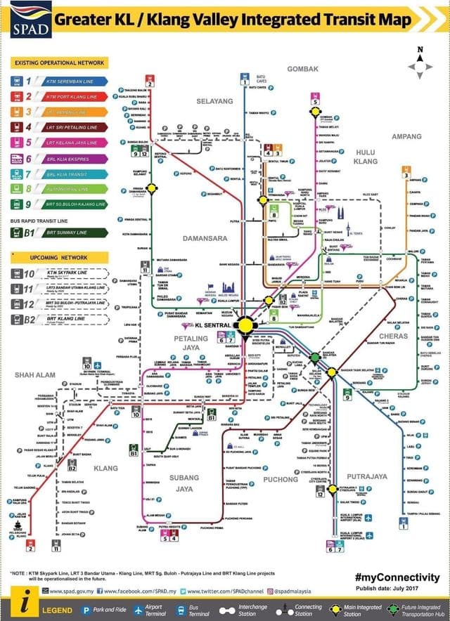
The Kuala Lumpur (KL) subway map shows all the stations and lines of the Kuala Lumpur (KL) subway. This subway map of Kuala Lumpur (KL) will allow you to easily plan your routes in the subway of Kuala Lumpur (KL) en Malaysia. The Kuala Lumpur (KL) subway map is downloadable in PDF, printable and free.
Although originally intended to be of LRT standard, the route, length and capacity levels of the Kajang Line were changed during planning. In 2011, construction of the city first full subway line began with revenue services commencing in late 2016 on the western section of the line and the full route opening in mid-2017. The line is mainly elevated, running underground for 9.5 km through the city centre in twin-bore tunnels (7 stations) as you can see in Kuala Lumpur (KL) subway map. The MRT is automated and driverless, using Siemens Inspiro 4-car trains with 4 to 7 min frequencies. Although owned by MRT Corp, the Kajang Line is operated by Rapid Kuala Lumpur (KL), with full integration to other Rapid KL services.